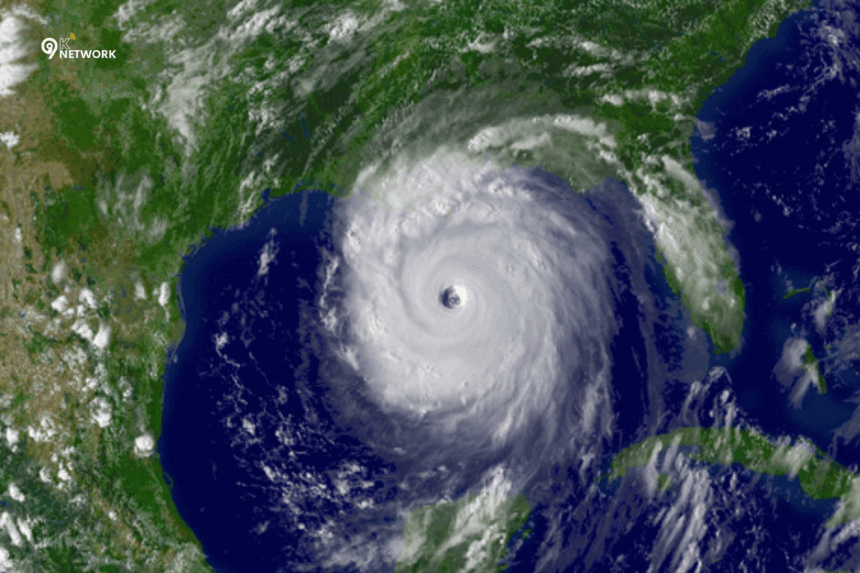
Hurricanes are among the most destructive natural disasters, causing significant damage to property, infrastructure, and lives. Staying informed and prepared is essential, especially for residents in hurricane-prone areas and small business owners whose operations can be severely impacted. NOAA hurricane tracking provides critical insights to help communities and businesses make timely decisions, mitigate risks, and safeguard lives. In this article, we explore NOAA’s role, hurricane tracking tools, preparedness strategies, and the latest updates for hurricane season 2025.
What is NOAA and Why Hurricane Tracking Matters
Understanding NOAA
NOAA stands for the National Oceanic and Atmospheric Administration, a U.S. federal agency responsible for monitoring weather, oceans, and the atmosphere. NOAA plays a pivotal role in tracking hurricanes and issuing alerts that help individuals, governments, and businesses take preventive measures. Through its advanced technology and forecasting systems, NOAA provides accurate data on storm paths, intensities, and potential landfall locations.
Importance of NOAA Hurricane Data
Accurate hurricane tracking saves lives. By providing early warnings, NOAA allows communities to evacuate, prepare emergency supplies, and safeguard property. For small business owners, NOAA hurricane data is critical in minimizing operational losses, protecting employees, and maintaining continuity during and after storms. Without such tracking, hurricane preparedness in states like Florida could be severely compromised.
Note: Cutting NOAA resources could jeopardize hurricane preparedness in vulnerable areas, leaving residents and businesses exposed to potentially devastating storms.
Key Features of NOAA Hurricane Tracking
Real-Time Hurricane Tracker
NOAA offers a live hurricane tracker that provides up-to-the-minute updates on active storms. This tool displays storm location, projected path, intensity, and wind speed. Residents can monitor tropical storms, hurricanes, and tropical depressions, helping them make timely decisions.
Key features include:
- Interactive maps showing storm tracks and forecast cones
- Mobile and desktop alerts for immediate updates
- Integration with local emergency notifications
Hurricane Forecasts and Alerts
Hurricane forecasts are crucial for risk management. NOAA provides detailed probable landfall predictions, storm categories, and expected intensities. Alerts are distributed through:
- TV and radio emergency broadcasts
- NOAA Weather Radio
- Mobile apps and official websites
Forecast accuracy has improved significantly over the years, giving communities more time to prepare and reducing the overall impact of storms.
Hurricane Season Updates
Hurricane season 2025 promises active monitoring, with NOAA already tracking potential storms. Historical trends indicate that Florida, Gulf Coast states, and the Eastern Seaboard are most at risk. Keeping updated with NOAA alerts ensures that residents and business owners remain vigilant throughout the season.
Example: NOAA recently issued updates on Hurricane Erin, providing projected paths and intensity forecasts to help residents prepare early.
Major Hurricanes and Lessons Learned
Most Powerful Hurricanes in History
Understanding past hurricanes helps us prepare better for the future. Some of the most significant hurricanes include:
| Hurricane | Year | Category | Impact |
|---|---|---|---|
| Katrina | 2005 | 5 | Over 1,800 deaths, $125B in damages |
| Andrew | 1992 | 5 | Widespread destruction in Florida, $27B in damages |
| Irma | 2017 | 5 | Massive destruction across Caribbean & Florida, $77B in damages |
| Gabrielle | 2001 | 3 | Heavy flooding, power outages in Florida |
These case studies highlight the importance of early warnings, evacuations, and proper preparedness measures.
Current Threats and Upcoming Storms
As of 2025, NOAA has been actively monitoring storms like Hurricane Gabrielle and Hurricane Erin. Using live trackers, residents can check:
- Storm category and intensity
- Predicted path and potential landfall
- Wind speed and rainfall projections
Early tracking allows local authorities to implement evacuation orders and emergency services to prepare for response.
How Residents and Small Businesses Can Stay Prepared
Creating an Emergency Plan
Preparedness begins with a clear emergency plan. Key components include:
- Identifying evacuation routes and safe shelters
- Stocking emergency supplies: food, water, medical kits
- Establishing a communication plan with family members or employees
Protecting Property and Assets
Small businesses and homeowners should focus on safeguarding property:
- Secure outdoor items and reinforce windows/doors
- Flood-proof basements and critical areas
- Ensure insurance coverage is up-to-date for hurricane-related damages
Using NOAA Resources Effectively
NOAA provides multiple tools to support preparedness:
- Live hurricane tracker for real-time monitoring
- Tropical storm update TODAY alerts for fast-changing conditions
- Mobile notifications for landfall warnings and evacuation advisories
Pro Tip: Bookmark NOAA’s official site and set notifications on your phone to receive timely updates on active hurricanes.
Common Questions About NOAA and Hurricanes (FAQ Section)
What does NOAA stand for in hurricanes?
NOAA is the National Oceanic and Atmospheric Administration, a federal agency that monitors weather, oceans, and atmospheric conditions to provide accurate hurricane forecasts and alerts.
Is Hurricane Erin expected to make landfall?
NOAA provides regular updates on Hurricane Erin’s projected path. Check the live hurricane tracker for the latest forecasts and alerts.
How accurate is NOAA hurricane tracking?
Modern NOAA tracking uses satellite imagery, radar, and predictive models, offering highly accurate forecasts that improve with every season.
When is hurricane season 2025?
Hurricane season typically runs from June 1 to November 30. NOAA provides updates throughout the season, tracking tropical storms and hurricanes in real-time.
How to use a live hurricane tracker?
Access NOAA’s interactive maps online or via mobile apps. Users can view storm paths, projected landfall, wind speeds, and category updates for immediate preparedness actions.
Conclusion
NOAA hurricane tracking is an essential tool for residents, small business owners, and meteorology enthusiasts. With accurate forecasts, live trackers, and early alerts, communities can stay prepared, minimize damage, and protect lives. Staying informed with NOAA updates ensures that Florida and other hurricane-prone areas remain vigilant throughout hurricane season 2025.
By following NOAA’s guidance, creating emergency plans, and leveraging tracking tools, you can take proactive steps to reduce risk and ensure safety during any tropical storm or hurricane event.
Stay updated. Stay prepared. Your safety is NOAA’s priority.
- Ultimate Guide to Tracking Storms Safely – Detailed guide on hurricane tracking and safety tips.


